Model Description
Some basic features of RIAM OCM are:
- Vertical z-coordinates and regular latitude-longitude B-grid
- Free surface with modes splitting
- Bousinesque approximation
- Ishizaki and Motoi's version of Takano-Onishi momentum advection scheme with diagonally upward and/or downward momentum fluxes
- Modified split QUICK scheme for tracer advection with upwind approximation at boundaries
- Isopycnal horizontal diffusion in small slope approximation and the Gent-McWilliams stiring for tracers
- Biharmonic horizontal friction
- Vertical (diapycnal) mixing approximation based on the turbulent kinetic energy budget model of Noh and Kim
- Implicit treatment of vertical momentum mixing and explicit-implicit vertical tracers mixing
- Modified boundary conditions scheme that takes into the account the tidal variations superimposed on mean inflow-outflow conditions
- Tidal module for estimation of tidal 'body force' and absolute tidal phases
- Grib Data Collections processing module for input and output of data in GRIB format with cubic spline time and bi-cubic spatial interpolation
- TOGA-COARE bulk parameterization of air-sea fluxes of Fairall et al.
- Parameterization for long-wave and short-wave radiative fluxes
- Management module that monitors and organizes all system operations
- Results presentation module
The short-term Japan Sea ocean prediction system operates routinely from September 2004 (version 1).
September 2007 the system operational cycle was modified. New 'version 2' system results are now available and recommended for utilization. Previous version 1 short-term modelling system was shut down October 2007.
System Operational Cycle (version 2.2)
RIAM short-term Japan Sea simulation model operates twice-daily creating 2 bulletins for 00 and 12 UTC every day. Model is initialized from the restart point shifted 24h backward from the bulletin date. New restart point is created 12 hours after the simulation was started. Nudging method is used to restore model time-mean temperature and salinity fields to these of the assimilation non-tidal Japan Sea model. From April, 2009 it is the Japan Sea Data Assimilation Experiment (JADE) modeling system operated by the Japan Fisheries Research Agency . This system provides the Japan Sea forecast and hindcast estimates by assimilating wide spectra of real-time observational data including in-situ CTD observations. Same model provides the mean open boundary conditions for our version of prediction system. Nudging time scale is taken as 10 days.
Tidal forcing is introduced in model as tidal potential and as the open boundary tidal sea level anomalies counted for 16 main tidal constituents (Japan National Astronomic Observatory, Matsumoto et.al.).
Atmospheric forcing is estimated by recent available hourly data of JMA MSM system (analyses and forecasts up to 33h), followed by the high-resolution regional output from the JMA global GSM system that provides hourly forecasts up to 84h followed by 3-hourly forecasts up to 192h (8 days). Meteorological analyses and forecasts are used to estimate surface wind stress, turbulent heat and fresh water exchange at the sea surface. TOGA-COARE bulk parameterization of air-sea fluxes of Fairall et al. is used. It is coupled with parameterization for radiative fluxes. Included are precipitation related effects as well as 'cool-warm-skin' estimation is done. However, as JMA GSM system from November 2007 provides forecast of accumulated precipitation for the variable total forecast time, temporaly the precipitation impact on surface heat and mass fluxes is counted only when JMA MSM data are available and disabled when switching to the JMA GSM forcing data.
Annual mean runoff of 5 largest rivers is counted, including the inflow of fresh water through the Nevelskogo (Mamiya) strait.
Model produces half-hourly ocean state estimates.
Data are organized as twice-daily bulletins with series of forecasts and continuous
"best estimates" data set with serie of hindcasts followed by latest available forecasts.
Time used in product labeling is the Greenvich mean time (UTC) that is -9h shifted from JMT (add 9h to get JMT).
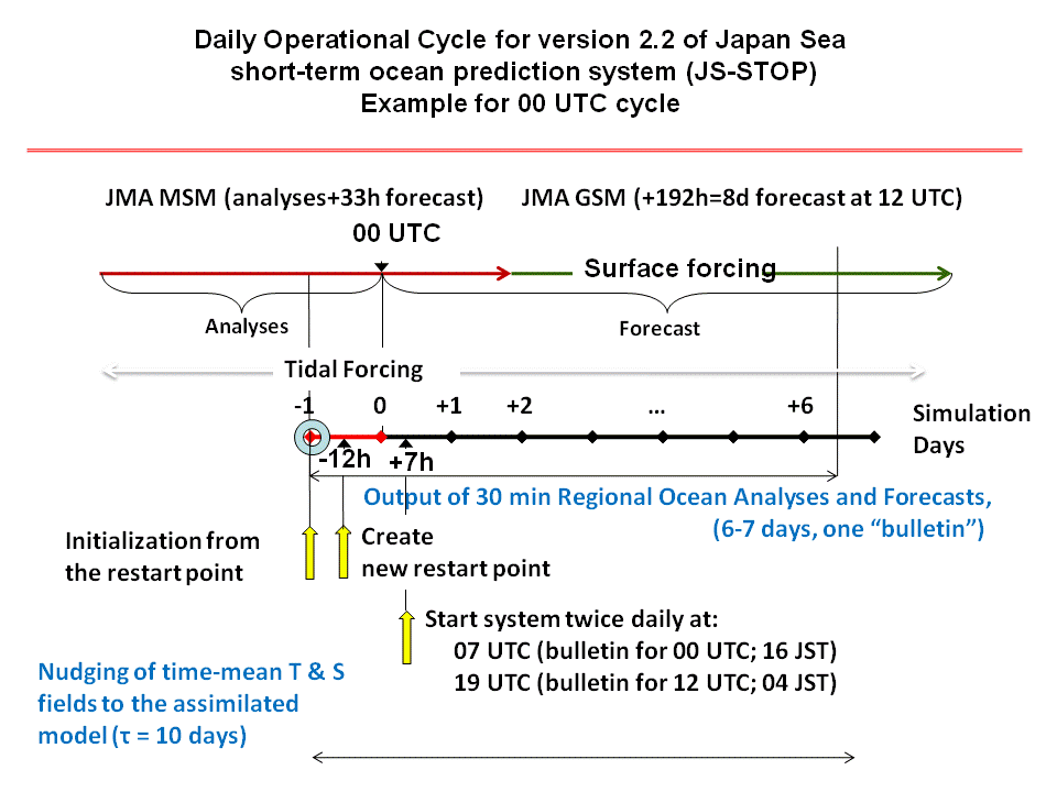
Figure above illustrates daily operations time-table.
For the graphical presentation of latest results please jump to the interactive data visualization page. Model output data could be accessed from the data download web page or following the "data set" link in the interactive data vizualization menu.